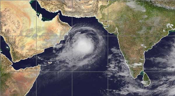
KARACHI: Arabian Sea Cyclone ‘Biparjoy’ that has intensified into an “extremely severe cyclonic storm” on Sunday morning has been 770 kilometer in south of Karachi.
The cyclonic storm now lies at a distance of about 770km south of Karachi, 750km south of Thatta and 860km southeast of Ormara, according to the weather report.
The cyclonic storm’s trajectory will likely to remain northwards. Maximum sustained surface winds are 140-160 Km/hour gusts 150 Km/hour around the system center and sea conditions being phenomenal around the system center with maximum wave height 30-40 feet.
According to weather reports Cyclone ‘Biparjoy’ is likely to make landfall between Karachi and Kutch district of Indian Gujarat on June 15, the India’s Meteorological Department (IMD) said in its forecast.
According to reports, the cyclone over the east-central Arabian Sea moved north-north-eastwards with a speed of nine km per hour during last six hours.
PMD in its late Saturday night advisory warned that the cyclone most likely to track further in north-northeast direction towards southeast Sindh-Indian Gujarat coast.
With its probable north-northeast track, the rain-thunderstorm with some very heavy falls and squally winds (60-80 Km/hour) are expected in southern or southeastern Sindh including Karachi, Thatta, Sujawal, Badin, Tharparker and Mirpurkhas districts) from 13 June (Tuesday) evening/night onwards.
The high intensity winds may cause damage to lose and vulnerable structures, the Met Office has cautioned. Storm surge of three meters (8-10 feet) can be possible.
The weather department has advised fishermen not to venture in open sea from 11 June (tomorrow) till the system is over as the Arabian Sea conditions may get very rough with high tides along the coast.
The Karachi Port Trust (KPT) on Saturday issued a ‘red alert’ as the Cyclonic Storm Biparjoy over the east-central Arabian Sea is maintaining its intensity.


